Physical Map of Italy
 Physical Map of Italy I made myself
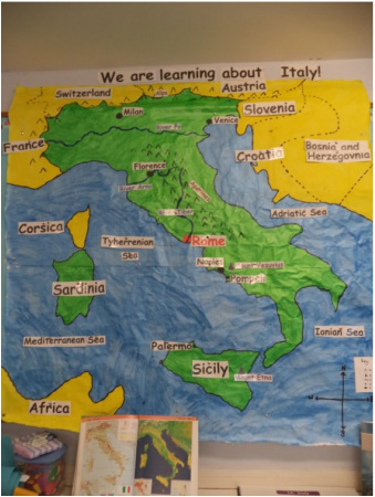
The Resource: 2-D large scale map of Italy (free hand drawn)
Description:
This is a 2-D large scale map of Italy showing some of the physical features:
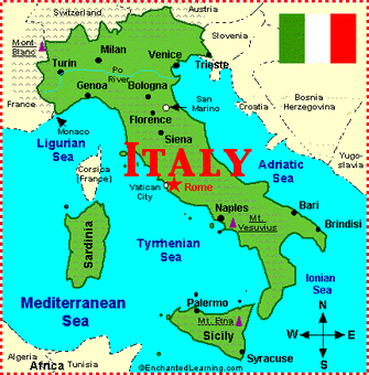
http://www.enchantedlearning.com/europe/italy/
http://www.ezilon.com/maps/europe/italy-physical-maps.html
Teaching Ideas and Activities:
-Children must use an atlas to label the large scale map as part of the class
-Children are given a blank map on A4 and must label the physical features using the large scale map of Italy and an atlas
-Labels of rivers/3 cities/mountains are removed and children must match the label to the correct feature on the map
If I were to teach this I would spend some time with the class revising how to read an atlas first. I would get the class to label the large-scale map as a class. I would introduce the cities and countries one day and the rivers, mountains and seas another day to ensure the children don't get confused. It would be important to refer to previous knowledge when introducing new features to consolidate material already learnt. It would be important to have a key for the map and the cardinal point symbol on the map.
Description:
This is a 2-D large scale map of Italy showing some of the physical features:
- the three main rivers (River Po, River Tiber, River Arno)
- Mountain ranges (Appenines, Alps)
- Volcanoes (Mount Etna, Mount Vesuvius)
- Bordering countries (France, Switzerland, Austria, Slovenia, Bosnia and Herzegovnia, Croatia and the continent of Africa)
- Seas (Adriatic Sea, Tyherrenian Sea)
- Main cities (Milan, Florence, Palermo, Naples, Venice and Pompeii)
- Capital (Rome)
http://www.enchantedlearning.com/europe/italy/
http://www.ezilon.com/maps/europe/italy-physical-maps.html
Teaching Ideas and Activities:
-Children must use an atlas to label the large scale map as part of the class
-Children are given a blank map on A4 and must label the physical features using the large scale map of Italy and an atlas
-Labels of rivers/3 cities/mountains are removed and children must match the label to the correct feature on the map
If I were to teach this I would spend some time with the class revising how to read an atlas first. I would get the class to label the large-scale map as a class. I would introduce the cities and countries one day and the rivers, mountains and seas another day to ensure the children don't get confused. It would be important to refer to previous knowledge when introducing new features to consolidate material already learnt. It would be important to have a key for the map and the cardinal point symbol on the map.
|
Curriculum Linkage:
This map formed part of my display for my TAP on Italy and was used as a meaningful learning tool to identify some of the physical features of Italy. History: The Roman Empire, Pompeii, Life in Ancient Rome Geography: Cities of Italy, Physical Features of Italy and Italian Food and Culture, Reading and Drawing Maps Visual Art: Draw own map of Italy (Free-hand) |
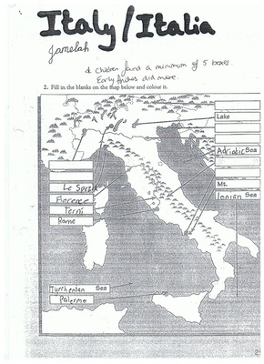
Children's work: Identifying some of the physical features of Italy using an Atlas
|
Physical map of Italy
|
Physical map of Italy
|
